Data with Bert logo

What I Do When I'm NOT Writing SQL

MJ-t-sql-TuesdayThis post is a response to this month's T-SQL Tuesday prompt created by Aaron BertrandAdam Machanic created T-SQL Tuesday as a way for SQL users to share ideas about interesting topics every month.  This month's topic is "Your passions outside of SQL Server".


Getting away

I spend most of my days in front of a computer.

While this is great because I love technology, a few times a year I like separating myself from all forms of semiconductors. I do this by going camping.

Watch this week's video on YouTube

I highly recommend watching this week's video on YouTube - I was able to include way more photos and video clips there!

Camping is a mental reset where I can focus on activities that are completely opposite of what I do every day. It involves different challenges and skill sets, and provides a literal breath of fresh air when compared to working in a typical office environment.

How did I come to enjoy sleeping on the ground and learning to survive with only 20lbs of gear? Let me describe three distinct eras in my camping evolution.

I didn't grow up camping

film-only-2 
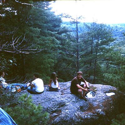
High school Bert's first camping trip in Vermont

My family never went on camping trips. I always enjoyed the outdoors, but I never learned any basic outdoors skills like you might learn in scouts.

My friends during high school came from similar upbringings. We didn't know anything about building campfires or sleeping in tents, but we wanted to learn.

So, during the summer before college we decided we'd drive up to Vermont, rent a campsite at a state park, and learn to live outdoors.

While an immensely fun trip, our skills were lacking since we basically ended up eating ramen and sleeping in our cars (because our incorrectly set up tent gushed with rainwater during the middle of the night).

We kept at it though, going back every summer, until we managed to figure out how things should work. After a few trips we were no longer eating just ramen and not needing to sleep in our cars anymore.

Have tent, will travel

My outdoor skills improved as I continued to camp through my college years; I learned to cook food over coals, stay dry during the harshest rain storms, and light fires with a single match instead of half a can of camping stove fuel.

During this time I also realized that could travel almost anywhere and have my accommodations cost less than \$20 per night PER CAMPSITE.

this-waters-too-warm-and-clear 
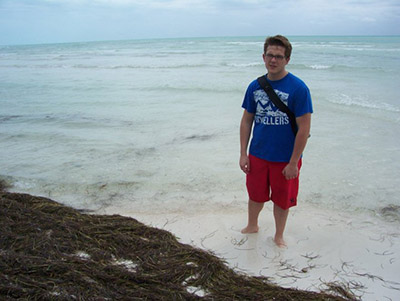
I must have been thinking "the water is too clear and warm for this New Englander"

This meant my friends (and future wife Renee) spent college spring break camping through the Everglades and the Florida Keys. We spent our days kayaking, zip lining, and eating key lime pies before returning to our ocean front campsite for the evening. I think in all that trip cost us less than \$400 per person for 9 days of fun, including gas for the minivan.

the-backpacking-view-3 
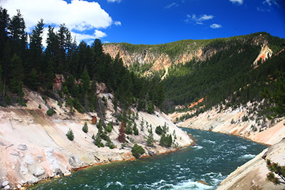
Ultra cheap vacation to Yellowstone National Park

Ultra cheap vacations continued and I now graduated to cooking single pot meals and foil packet dinners. My car was still parked nearby but I wasn't having to sleep in it at night.

I even ventured back to Vermont and proposed to Renee there while camping (she said yes even after three days of no showers. That's when I knew she was a keeper).

Backpacking and gourmet food

better-than-any-hotel 
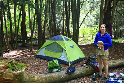
Everything we need, carried in and carried out.

Camping eventually evolved into backpacking - instead of having a car a few feet away with a cooking stove and cooler of cold food, now I was learning about how to go into the wilderness for days with everything I would need carried in on my back.

Backpacking is truly exciting. You get to go and see places only accessible by a long hike on foot. The trips require more planning, both in terms of hiking routes, food preparation, water scouting, wildlife management, etc.... all things that invigorate my researching, detail oriented personality.

Living out of a backpack also means that you can easily fly to locations and still have a cheap vacation. I got to see beautiful National Parks like Yellowstone, the Grand Tetons, and Shenandoah all because I knew how to fit everything I need to survive into a carry-on and personal item (except for stove fuel, bear spray, and pocket knife ...some things you just have to buy on location).

Not only is visiting these places cool to begin with, but camping overnight in them means you get to see the park early before any car driving tourists arrive and you get to stay out way longer after they all leave the park to go grab dinner.

By this point my car is parked miles away from where I am sleeping and my food game has stepped up. Although I am limited to carrying everything I need in a pack, we frequently dine on pad thai, pizza, and cinnamon rolls.

pizza 
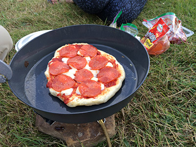
After a long day spent hiking...

cinnamon-rolls 
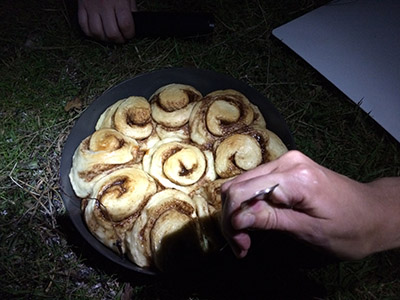
... these are the only foods I need to eat.

Who says you need to be roughing it while camping?

"How do I contribute to dbatools?" with Drew Furgiuele

Watch this week's video on YouTube

This weekend I caught up with Drew Furgiuele at SQL Saturday Cleveland and learned how to get involved with the open-source dbatools PowerShell module.

If you don't use dbatools yet, what are you waiting for?  It's an amazing community project that will help you automate your SQL Server work with over 350 ready-to-use commands.

After you start using dbatools, you might think of new commands you want to add or other features you want to improve - and the best part is that you can!

Even if writing PowerShell commands isn't one of your strengths, there are many ways you can contribute to this excellent community project as Drew mentions in the video above.

The Fastest Way To Locate Errors In Your SQL Query

n-120570-2

In about 60 seconds you will never debug error messages in SQL Server Management Studio the same way again.

Coming from a .NET background, I'm used to receiving relatively helpful error messages that point me to the precise location of the error in my code:

NET-Error-Message Pinpoint error finding

SQL Server Management Studio does a decent job too - **except when it doesn't. ** Different versions of SSMS provide error line numbers differently.

Watch this week's video on YouTube

In older versions (<= 2012), SSMS provides error location information relative to the batch starting point of the erroneous query.  This means if you have a window full of T-SQL batch statements, your error message will be relative to the last "GO" in the editor before the syntax error:

Error-message-in-old-SSMS

In SSMS 2014, batch start locations aren't considered:

error-message-ssms-2014

Starting in SSMS 2016, the error messages revert back to counting from the current batch but also indicate the line number where the batch begins:

Error-message-in-newer-ssms

While all of these error messages point me in the right direction, I'm too lazy to try and remember how each version of SSMS refers to the error location.  This becomes particularly problematic when jumping around environments and not being able to use a consistent version of SSMS.

There is one feature that works consistently though that makes navigating to the specific error lines easily.

You can double click on the error message to be taken directly to the line number referenced!

I know this sounds simple, but it's one of those small things I never thought of trying until I saw someone else do it.  Little did I know what I was missing out on - especially in those giant hundreds/thousands of line long scripts.  but now that I know about it it's the only way I locate my query errors.

This functionality also works if you have multiple errors listed in the Messages window.

But what about if your SQL query is all on one giant line (like if it was copied from somewhere or generated dynamically)?  You can use a regular expression to format your query first and then click on the error message to quickly navigate to the correct lines.

Inverted Polygons? How to Troubleshoot SQL Server's Left Hand Rule

inverted-polygon

Last week we looked at how easy it is to import GeoJSON data into SQL Server's geography datatype.

Sometimes your source data won't be perfectly formatted for SQL Server's spatial datatypes though.

Today we'll examine what to do when our geographical polygon is showing us inverted results.

Watch this week's video on YouTube

Colorado Is A Rectangle

If you look at the state of Colorado on a map, you'll notice its border is pretty much a rectangle.

Roughly marking the lat/long coordinates of the state's four corners will give you a polygon comprised of the following points:

colorado-map-lat-longs-1

Or in GeoJSON format (set equal to a SQL variable) you might represent this data like so:

DECLARE @Colorado nvarchar(max) = N'
{
    "type": "FeatureCollection",
    "features": [{
        "type": "Feature",
        "properties": {},
        "geometry": {
            "type": "Polygon",
            "coordinates": [
                [
                    [-109.05005693435669,
                        41.0006946252774
                    ],
                    [-102.05157816410065,
                        41.002362600596015
                    ],
                    [-102.0421314239502,
                        36.993139985820925
                    ],
                    [-109.04520750045776,
                        36.99898824162522
                    ],

                    [-109.05005693435669,
                        41.0006946252774
                    ]
                ]
            ]
        }
    }]
}
'

Note: four points + one extra point that is a repeat of our first point - this last repeated point let's us know that we have a closed polygon since it ends at the same point where it began.

Viewing Our Colorado Polygon

Converting this array of points to the SQL Server geography datatype is pretty straight forward:

SELECT
    geography::STPolyFromText(
        'POLYGON ((' + STRING_AGG(CAST(Long + ' ' + Lat as varchar(max)), ',') + '))'
        ,4326) AS StateBoundary
FROM
    (
    SELECT 
        Long,
        Lat
    FROM
        OPENJSON(@Colorado, '$.features[0].geometry.coordinates[0]')
        WITH
            (
                Long varchar(100) '$[0]',
                Lat varchar(100) '$[1]'
            )
)d

We can then take a look at SQL Server Management Studio's Spatial Results tab and see our polygon of Colorado drawn on a map.  You might notice something looks a little funny with this picture though:

spatial-results-inverted-rectangle

WHY IS MY POLYGON AREA INVERTED?!!??!

Discerning eyes might notice that SQL Server didn't shade in the area inside of the polygon - it instead shaded in everything in the world EXCEPT for the interior of our polygon.

If this is the first time you've encountered this behavior then you're probably confused by this behavior - I know I was.

The Left-Hand/Right-Hand Rules

There is a logical explanation though for why SQL Server is seemingly shading in the wrong part of our polygon.

SQL Server's geography datatype follows the "left-hand rule" when determining which side of the polygon should be shaded.  On the contrary, the GeoJSON specification specifies objects should be formed following the "right-hand rule."

The left hand rule works like this: imagine you are walking the path of polygon - whatever is to the left of the line you are walking is what is considered the "interior" of that polygon.

So if we draw arrows that point in the direction that the coordinates are listed in our GeoJSON, you'll notice we are making our polygon in a clockwise direction:

arrows-2

If you imagine yourself walking along this line in the direction specified, you'll quickly see why SQL Server shades the "outside" of the polygon: following the left-hand rule, everything except for the state of Colorado is considered the interior of our polygon shape.

Reversing Polygon Direction

So the problem here is that our polygon data was encoded in a different direction than the SQL Server geography datatype expects.

One way to fix this is to correct our source data by reordering the points so that the polygon is drawn in a counter-clockwise direction:

-- Note: The middle three sets of points have been included in reverse order while the first/last point have stayed the same
DECLARE @ColoradoReversed nvarchar(max) = N'
{
    "type": "FeatureCollection",
    "features": [{
        "type": "Feature",
        "properties": {},
        "geometry": {
            "type": "Polygon",
            "coordinates": [
                [
                    [-109.05005693435669,
                        41.0006946252774
                    ],
                    [-109.04520750045776,
                        36.99898824162522
                    ],
                    [-102.0421314239502,
                        36.993139985820925
                    ],

                    [-102.05157816410065,
                        41.002362600596015
                    ],

                    [-109.05005693435669,
                        41.0006946252774
                    ]
                ]
            ]
        }
    }]
}
'

This is pretty easy to do with a polygon that only has five points, but this would be a huge pain for a polygon with hundreds or thousands of points.

So how do we solve this in a more efficient manner?

Easy, use SQL Server's ReorientObject() function.

SELECT
    geography::STPolyFromText(
        'POLYGON ((' + STRING_AGG(CAST(Long + ' ' + Lat as varchar(max)), ',') + '))'
        ,4326).ReorientObject() AS StateBoundary
FROM
    (
    SELECT 
        Long,
        Lat
    FROM
        OPENJSON(@Colorado, '$.features[0].geometry.coordinates[0]')
        WITH
            (
                Long varchar(100) '$[0]',
                Lat varchar(100) '$[1]'
            )
)d

ReorientObject() does what we did manually above - it manipulates the order of our polygon's points so that it changes the direction in which the polygon is drawn.

Note: SQL uses a different order when reversing the points using ReorientObject() than the way we reversed them above.  The end result ends up being the same however.

Regardless of which method you choose to use, the results are the same: our polygon of Colorado is now drawn in the correct direction and the Spatial Results tab visually confirms this for us:

spatial-correct-results

Importing GeoJSON Earthquake Data Into SQL Server

IMG_0397 A significant portion of Yellowstone National Park sits on top of a supervolcano.  Although it's not likely to erupt any time soon, the park is constantly monitored for geological events like earthquakes.

This week I want to take a look at how you can import this earthquake data, encoded in GeoJSON format, into SQL Server in order to be able to analyze it using SQL Server's spatial functions.

Watch this week's video on YouTube

GeoJSON

The source for the data we'll be using is the 30-day earthquake feed from the USGS.  This data is encoded in the GeoJSON format, a specification that makes it easy to share spatial data via JSON.  To get an idea of how it looks, here's an extract:

{
    "type": "FeatureCollection",
    "metadata": {
        "generated": 1515603955000,
        "url": "https://earthquake.usgs.gov/earthquakes/feed/v1.0/summary/1.0_month.geojson",
        "title": "USGS Magnitude 1.0+ Earthquakes, Past Month",
        ...
    },
    "features": [{
            "type": "Feature",
            "properties": {
                "mag": 1.25,
                "place": "7km NW of The Geysers, CA",
                "time": 1515603166510,
                ...
            },
            "geometry": {
                "type": "Point",
                "coordinates": [-122.8221664, 38.8175011, 2.02]
            },
            "id": "nc72952110"
        },
        ...
        ],
    "bbox": [-179.921, -62.519, -3.35, 179.9551, 85.3951, 608.58]
}

The key thing we'll be examining in this data is the "features" array: it contains one feature object for each earthquake that's been recorded in the past 30 days.  You can see the "geometry" child object contains lat/long coordinates that we'll be importing into SQL Server.

If you want the same 30-day GeoJSON extract we'll be using in all of the following demo code, you can download it here.

Importing GeoJSON into SQL Server

There's no out of the box way to import GeoJSON data into SQL Server.

However, using SQL Server's JSON functions we can build our own solution pretty easily.

First, let's create a table where we can store all of earthquake data:

CREATE TABLE dbo.EarthquakeData
(
    Id int IDENTITY PRIMARY KEY,
    EventDate DATETIME2,
    Magnitude FLOAT,
    Place VARCHAR(300),
    Coordinates GEOGRAPHY,
    Long varchar(100),
    Lat varchar(100)
)

CREATE SPATIAL INDEX IX_Coordinates ON dbo.EarthquakeData (Coordinates)

Then, let's use the OPENJSON() function to parse our JSON and insert it into our table:

DECLARE @GeoJSON nvarchar(max) = N'{...}' -- Put the GeoJSON here

INSERT INTO dbo.EarthquakeData (EventDate,Magnitude,Place,Coordinates,Long,Lat)
SELECT 
    -- Convert unix epoch time to datetime
    -- We also know the source is in UTC, so we specify that using AT TIME ZONE for easier conversions down the road
    DATEADD(second,cast(UnixMillisecondsSinceEpoch/1000 as int),'1970-01-01 00:00:00') AT TIME ZONE 'UTC' AS EventDate,
    Magnitude,
    Place,
    -- Build our geography datatype
    geography::STPointFromText('POINT ('+Long + ' ' + Lat + ')', 4326) AS Geography,
    Long,
    Lat
FROM 
    OPENJSON(@GeoJSON, '$.features')
        WITH (
            UnixMillisecondsSinceEpoch bigint '$.properties.time',
            Magnitude float '$.properties.mag',
            Place varchar(300) '$.properties.place',
            Long varchar(100) '$.geometry.coordinates[0]',
            Lat varchar(100) '$.geometry.coordinates[1]'
        )

We use OPENJSON() to parse our JSON hierarchy and then concatenate together the lat and long values into our well known text format to be able to use it with SQL Server's spatial function STPointFromText:

SELECT geography::STPointFromText('POINT ('+Long + ' ' + Lat + ')', 4326) AS Geography

What results is our earthquake data all nicely parsed out into our dbo.EarthquakeData table:

Earthquake-data-parsed

What about Yellowstone?

The above data includes earthquakes from around world.  Since we only want to examine earthquakes in Yellowstone, we'll need to filter the data out.

There's a handy Place column in the data that we could probably add a LIKE '%yellowstone%' filter to - but this is a post about spatial data in SQL, we can do better!

The Wyoming State Geological Survey website has Shapefiles for the boundary of Yellowstone National Park.  Since we are practicing our GeoJSON import skills, I converted the Shapefiles to GeoJSON using an online converter and the resulting data looks like this:

{
    "type": "FeatureCollection",
    "bbox": [-111.15354785438899, 44.13238494057162, -109.816111731858, 45.102865336505396],
    "features": [{
        "type": "Feature",
        "geometry": {
            "type": "Polygon",
            "coordinates": [
                [
                    [-111.0970801722779, 44.487322588834374],
                    [-111.09707931336956, 44.48929779632266],
                    [-111.09707877845554, 44.49109904485493],
                    [-111.09707888353985, 44.49472122457225],.
                    ...
                ]
            ]
        },
        ...
    }]
}

You can download the full park boundary GeoJSON file here.

Just like before, we'll use SQL Server's OPENJSON() function to parse our GeoJSON data into a well-known text POLYGON.

First we create our table:

DROP TABLE IF EXISTS dbo.ParkBoundaries
CREATE TABLE dbo.ParkBoundaries
(
    Id int IDENTITY PRIMARY KEY,
    ParkName varchar(100),
    ParkBoundary GEOGRAPHY
)
CREATE SPATIAL INDEX IX_Boundary ON dbo.ParkBoundaries (ParkBoundary)

And then populate it, this time using the STPolyFromText spatial function:

INSERT INTO dbo.ParkBoundaries (ParkName, ParkBoundary)
SELECT
    'Yellowstone National Park' AS ParkName,
    geography::STPolyFromText('POLYGON ((' + STRING_AGG(CAST(Long + ' ' + Lat as varchar(max)), ',') + '))',4326).ReorientObject() AS ParkBoundary
FROM
    (
    SELECT 
        Long,
        Lat
    FROM
        OPENJSON(@Yellowstone, '$.features[0].geometry.coordinates[0]')
        WITH
            (
                Long varchar(100) '$[0]',
                Lat varchar(100) '$[1]'
            )
)d

Filtering our data

Now we have two tables: dbo.EarthquakeData and dbo.ParkBoundaries.  What we want to do is select only the Earthquake data points that fall within the boundaries of Yellowstone National Park.

This is easy to do using the STIntersects spatial function, which returns a "1" for any rows where one geography instance (our lat/long earthquake coordinate) intersects another geography instance (our park boundary):

SELECT 
    d.Id,
    d.Magnitude,
    d.EventDate,
    d.Place,
    b.ParkName
FROM 
    dbo.EarthQuakeData d
    CROSS JOIN dbo.ParkBoundaries b
WHERE
    Coordinates.STIntersects(ParkBoundary) =1
    AND b.ParkName = 'Yellowstone National Park'
ORDER BY
    Magnitude DESC

The rest is up to you

So all it takes to import GeoJSON data into SQL Server is knowing how to use SQL Server's JSON functions.

Once geographical data is imported into geography data types, SQL Server's spatial functions offer lots of flexibility for how to efficiently slice and dice the data.