Inverted Polygons? How to Troubleshoot SQL Server's Left Hand Rule

inverted-polygon

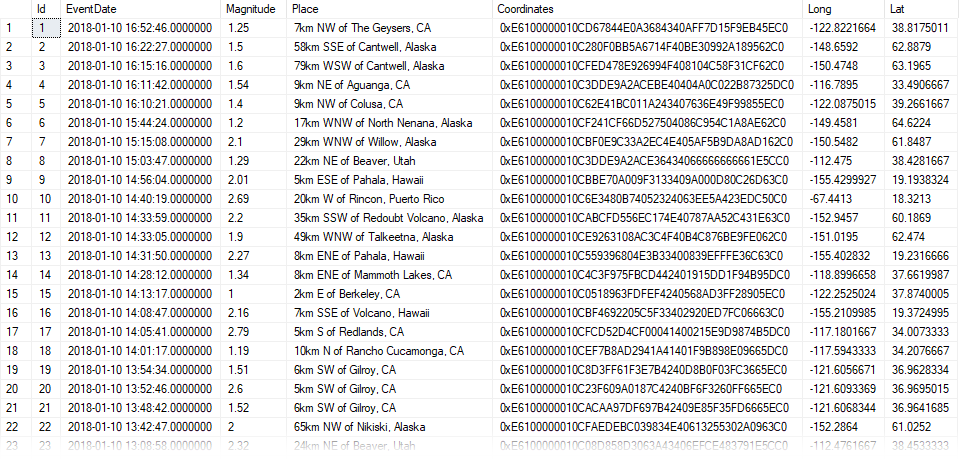
Last week we looked at how easy it is to import GeoJSON data into SQL Server's geography datatype.

Sometimes your source data won't be perfectly formatted for SQL Server's spatial datatypes though.

Today we'll examine what to do when our geographical polygon is showing us inverted results.

Watch this week's video on YouTube

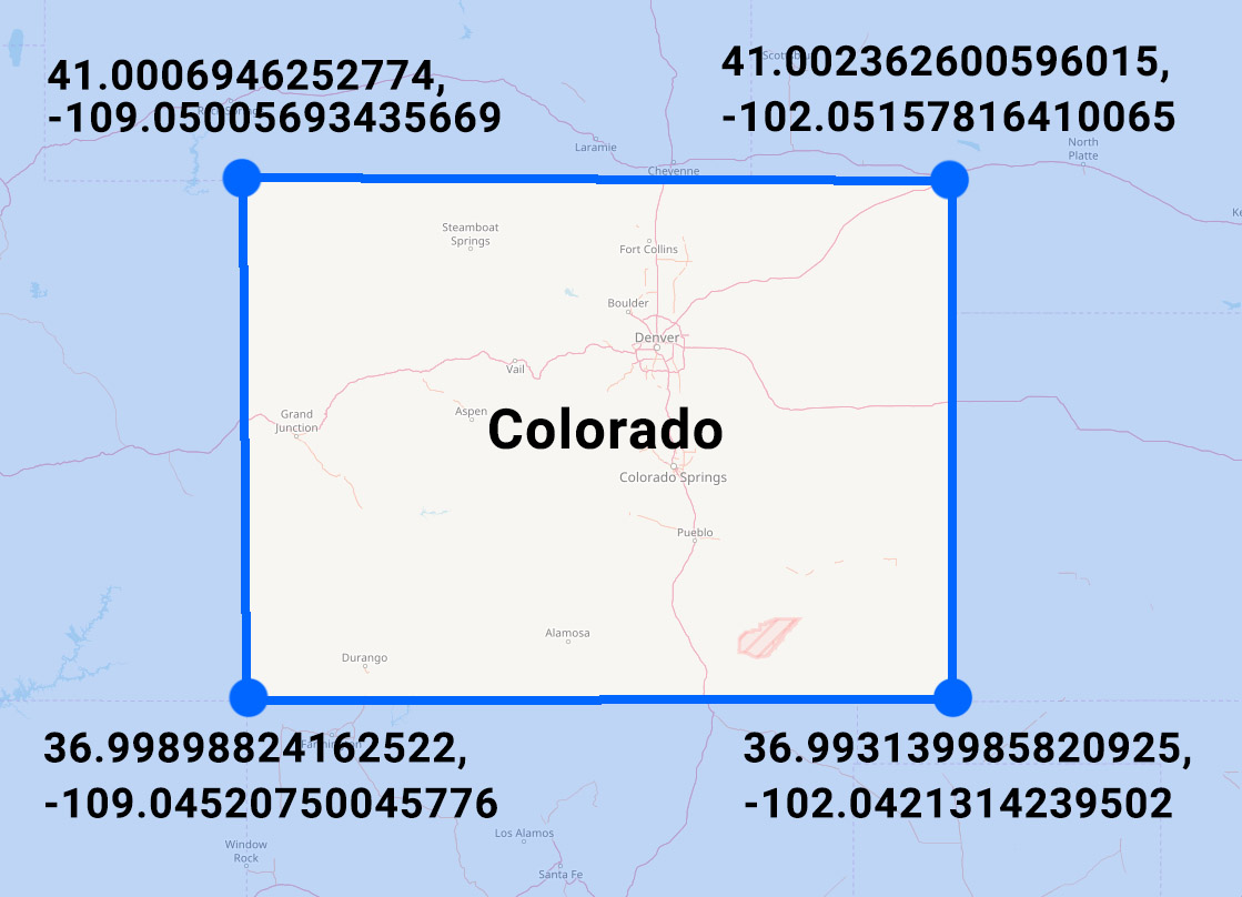
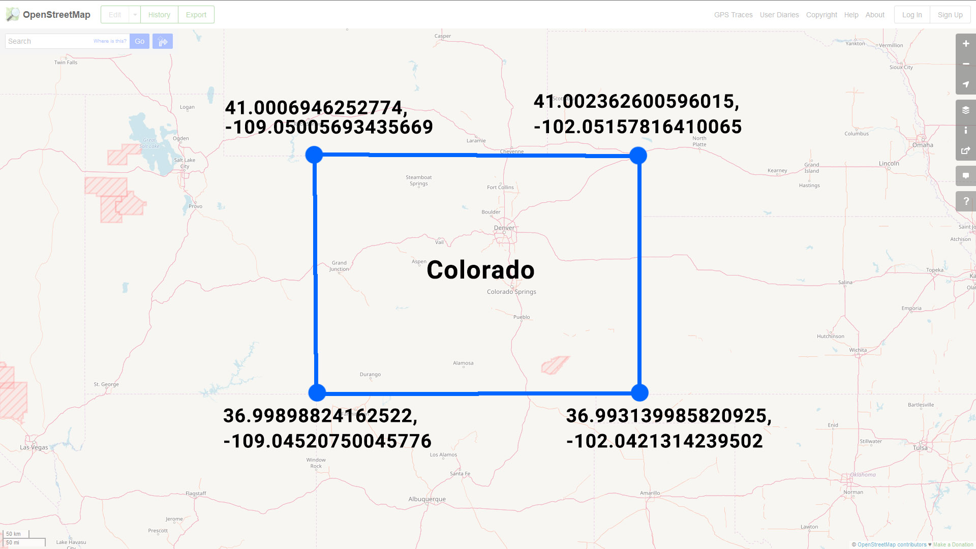
Colorado Is A Rectangle

If you look at the state of Colorado on a map, you'll notice its border is pretty much a rectangle.

Roughly marking the lat/long coordinates of the state's four corners will give you a polygon comprised of the following points:

colorado-map-lat-longs-1

Or in GeoJSON format (set equal to a SQL variable) you might represent this data like so:

DECLARE @Colorado nvarchar(max) = N'
{
    "type": "FeatureCollection",
    "features": [{
        "type": "Feature",
        "properties": {},
        "geometry": {
            "type": "Polygon",
            "coordinates": [
                [
                    [-109.05005693435669,
                        41.0006946252774
                    ],
                    [-102.05157816410065,
                        41.002362600596015
                    ],
                    [-102.0421314239502,
                        36.993139985820925
                    ],
                    [-109.04520750045776,
                        36.99898824162522
                    ],

                    [-109.05005693435669,
                        41.0006946252774
                    ]
                ]
            ]
        }
    }]
}
'

Note: four points + one extra point that is a repeat of our first point - this last repeated point let's us know that we have a closed polygon since it ends at the same point where it began.

Viewing Our Colorado Polygon

Converting this array of points to the SQL Server geography datatype is pretty straight forward:

SELECT
    geography::STPolyFromText(
        'POLYGON ((' + STRING_AGG(CAST(Long + ' ' + Lat as varchar(max)), ',') + '))'
        ,4326) AS StateBoundary
FROM
    (
    SELECT 
        Long,
        Lat
    FROM
        OPENJSON(@Colorado, '$.features[0].geometry.coordinates[0]')
        WITH
            (
                Long varchar(100) '$[0]',
                Lat varchar(100) '$[1]'
            )
)d

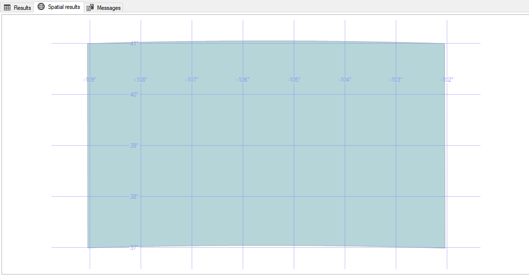
We can then take a look at SQL Server Management Studio's Spatial Results tab and see our polygon of Colorado drawn on a map.  You might notice something looks a little funny with this picture though:

spatial-results-inverted-rectangle

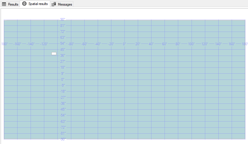
WHY IS MY POLYGON AREA INVERTED?!!??!

Discerning eyes might notice that SQL Server didn't shade in the area inside of the polygon - it instead shaded in everything in the world EXCEPT for the interior of our polygon.

If this is the first time you've encountered this behavior then you're probably confused by this behavior - I know I was.

The Left-Hand/Right-Hand Rules

There is a logical explanation though for why SQL Server is seemingly shading in the wrong part of our polygon.

SQL Server's geography datatype follows the "left-hand rule" when determining which side of the polygon should be shaded.  On the contrary, the GeoJSON specification specifies objects should be formed following the "right-hand rule."

The left hand rule works like this: imagine you are walking the path of polygon - whatever is to the left of the line you are walking is what is considered the "interior" of that polygon.

So if we draw arrows that point in the direction that the coordinates are listed in our GeoJSON, you'll notice we are making our polygon in a clockwise direction:

arrows-2

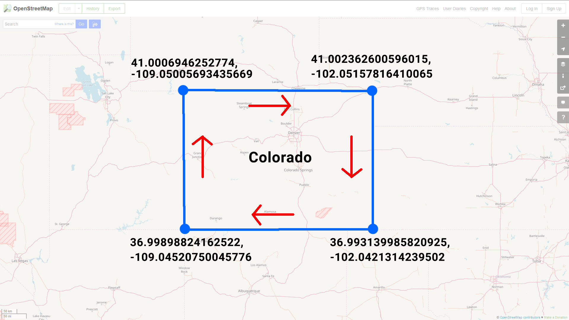
If you imagine yourself walking along this line in the direction specified, you'll quickly see why SQL Server shades the "outside" of the polygon: following the left-hand rule, everything except for the state of Colorado is considered the interior of our polygon shape.

Reversing Polygon Direction

So the problem here is that our polygon data was encoded in a different direction than the SQL Server geography datatype expects.

One way to fix this is to correct our source data by reordering the points so that the polygon is drawn in a counter-clockwise direction:

-- Note: The middle three sets of points have been included in reverse order while the first/last point have stayed the same
DECLARE @ColoradoReversed nvarchar(max) = N'
{
    "type": "FeatureCollection",
    "features": [{
        "type": "Feature",
        "properties": {},
        "geometry": {
            "type": "Polygon",
            "coordinates": [
                [
                    [-109.05005693435669,
                        41.0006946252774
                    ],
                    [-109.04520750045776,
                        36.99898824162522
                    ],
                    [-102.0421314239502,
                        36.993139985820925
                    ],

                    [-102.05157816410065,
                        41.002362600596015
                    ],

                    [-109.05005693435669,
                        41.0006946252774
                    ]
                ]
            ]
        }
    }]
}
'

This is pretty easy to do with a polygon that only has five points, but this would be a huge pain for a polygon with hundreds or thousands of points.

So how do we solve this in a more efficient manner?

Easy, use SQL Server's ReorientObject() function.

SELECT
    geography::STPolyFromText(
        'POLYGON ((' + STRING_AGG(CAST(Long + ' ' + Lat as varchar(max)), ',') + '))'
        ,4326).ReorientObject() AS StateBoundary
FROM
    (
    SELECT 
        Long,
        Lat
    FROM
        OPENJSON(@Colorado, '$.features[0].geometry.coordinates[0]')
        WITH
            (
                Long varchar(100) '$[0]',
                Lat varchar(100) '$[1]'
            )
)d

ReorientObject() does what we did manually above - it manipulates the order of our polygon's points so that it changes the direction in which the polygon is drawn.

Note: SQL uses a different order when reversing the points using ReorientObject() than the way we reversed them above.  The end result ends up being the same however.

Regardless of which method you choose to use, the results are the same: our polygon of Colorado is now drawn in the correct direction and the Spatial Results tab visually confirms this for us:

spatial-correct-results

Importing GeoJSON Earthquake Data Into SQL Server

IMG_0397 A significant portion of Yellowstone National Park sits on top of a supervolcano.  Although it's not likely to erupt any time soon, the park is constantly monitored for geological events like earthquakes.

This week I want to take a look at how you can import this earthquake data, encoded in GeoJSON format, into SQL Server in order to be able to analyze it using SQL Server's spatial functions.

Watch this week's video on YouTube

GeoJSON

The source for the data we'll be using is the 30-day earthquake feed from the USGS.  This data is encoded in the GeoJSON format, a specification that makes it easy to share spatial data via JSON.  To get an idea of how it looks, here's an extract:

{
    "type": "FeatureCollection",
    "metadata": {
        "generated": 1515603955000,
        "url": "https://earthquake.usgs.gov/earthquakes/feed/v1.0/summary/1.0_month.geojson",
        "title": "USGS Magnitude 1.0+ Earthquakes, Past Month",
        ...
    },
    "features": [{
            "type": "Feature",
            "properties": {
                "mag": 1.25,
                "place": "7km NW of The Geysers, CA",
                "time": 1515603166510,
                ...
            },
            "geometry": {
                "type": "Point",
                "coordinates": [-122.8221664, 38.8175011, 2.02]
            },
            "id": "nc72952110"
        },
        ...
        ],
    "bbox": [-179.921, -62.519, -3.35, 179.9551, 85.3951, 608.58]
}

The key thing we'll be examining in this data is the "features" array: it contains one feature object for each earthquake that's been recorded in the past 30 days.  You can see the "geometry" child object contains lat/long coordinates that we'll be importing into SQL Server.

If you want the same 30-day GeoJSON extract we'll be using in all of the following demo code, you can download it here.

Importing GeoJSON into SQL Server

There's no out of the box way to import GeoJSON data into SQL Server.

However, using SQL Server's JSON functions we can build our own solution pretty easily.

First, let's create a table where we can store all of earthquake data:

CREATE TABLE dbo.EarthquakeData
(
    Id int IDENTITY PRIMARY KEY,
    EventDate DATETIME2,
    Magnitude FLOAT,
    Place VARCHAR(300),
    Coordinates GEOGRAPHY,
    Long varchar(100),
    Lat varchar(100)
)

CREATE SPATIAL INDEX IX_Coordinates ON dbo.EarthquakeData (Coordinates)

Then, let's use the OPENJSON() function to parse our JSON and insert it into our table:

DECLARE @GeoJSON nvarchar(max) = N'{...}' -- Put the GeoJSON here

INSERT INTO dbo.EarthquakeData (EventDate,Magnitude,Place,Coordinates,Long,Lat)
SELECT 
    -- Convert unix epoch time to datetime
    -- We also know the source is in UTC, so we specify that using AT TIME ZONE for easier conversions down the road
    DATEADD(second,cast(UnixMillisecondsSinceEpoch/1000 as int),'1970-01-01 00:00:00') AT TIME ZONE 'UTC' AS EventDate,
    Magnitude,
    Place,
    -- Build our geography datatype
    geography::STPointFromText('POINT ('+Long + ' ' + Lat + ')', 4326) AS Geography,
    Long,
    Lat
FROM 
    OPENJSON(@GeoJSON, '$.features')
        WITH (
            UnixMillisecondsSinceEpoch bigint '$.properties.time',
            Magnitude float '$.properties.mag',
            Place varchar(300) '$.properties.place',
            Long varchar(100) '$.geometry.coordinates[0]',
            Lat varchar(100) '$.geometry.coordinates[1]'
        )

We use OPENJSON() to parse our JSON hierarchy and then concatenate together the lat and long values into our well known text format to be able to use it with SQL Server's spatial function STPointFromText:

SELECT geography::STPointFromText('POINT ('+Long + ' ' + Lat + ')', 4326) AS Geography

What results is our earthquake data all nicely parsed out into our dbo.EarthquakeData table:

Earthquake-data-parsed

What about Yellowstone?

The above data includes earthquakes from around world.  Since we only want to examine earthquakes in Yellowstone, we'll need to filter the data out.

There's a handy Place column in the data that we could probably add a LIKE '%yellowstone%' filter to - but this is a post about spatial data in SQL, we can do better!

The Wyoming State Geological Survey website has Shapefiles for the boundary of Yellowstone National Park.  Since we are practicing our GeoJSON import skills, I converted the Shapefiles to GeoJSON using an online converter and the resulting data looks like this:

{
    "type": "FeatureCollection",
    "bbox": [-111.15354785438899, 44.13238494057162, -109.816111731858, 45.102865336505396],
    "features": [{
        "type": "Feature",
        "geometry": {
            "type": "Polygon",
            "coordinates": [
                [
                    [-111.0970801722779, 44.487322588834374],
                    [-111.09707931336956, 44.48929779632266],
                    [-111.09707877845554, 44.49109904485493],
                    [-111.09707888353985, 44.49472122457225],.
                    ...
                ]
            ]
        },
        ...
    }]
}

You can download the full park boundary GeoJSON file here.

Just like before, we'll use SQL Server's OPENJSON() function to parse our GeoJSON data into a well-known text POLYGON.

First we create our table:

DROP TABLE IF EXISTS dbo.ParkBoundaries
CREATE TABLE dbo.ParkBoundaries
(
    Id int IDENTITY PRIMARY KEY,
    ParkName varchar(100),
    ParkBoundary GEOGRAPHY
)
CREATE SPATIAL INDEX IX_Boundary ON dbo.ParkBoundaries (ParkBoundary)

And then populate it, this time using the STPolyFromText spatial function:

INSERT INTO dbo.ParkBoundaries (ParkName, ParkBoundary)
SELECT
    'Yellowstone National Park' AS ParkName,
    geography::STPolyFromText('POLYGON ((' + STRING_AGG(CAST(Long + ' ' + Lat as varchar(max)), ',') + '))',4326).ReorientObject() AS ParkBoundary
FROM
    (
    SELECT 
        Long,
        Lat
    FROM
        OPENJSON(@Yellowstone, '$.features[0].geometry.coordinates[0]')
        WITH
            (
                Long varchar(100) '$[0]',
                Lat varchar(100) '$[1]'
            )
)d

Filtering our data

Now we have two tables: dbo.EarthquakeData and dbo.ParkBoundaries.  What we want to do is select only the Earthquake data points that fall within the boundaries of Yellowstone National Park.

This is easy to do using the STIntersects spatial function, which returns a "1" for any rows where one geography instance (our lat/long earthquake coordinate) intersects another geography instance (our park boundary):

SELECT 
    d.Id,
    d.Magnitude,
    d.EventDate,
    d.Place,
    b.ParkName
FROM 
    dbo.EarthQuakeData d
    CROSS JOIN dbo.ParkBoundaries b
WHERE
    Coordinates.STIntersects(ParkBoundary) =1
    AND b.ParkName = 'Yellowstone National Park'
ORDER BY
    Magnitude DESC

The rest is up to you

So all it takes to import GeoJSON data into SQL Server is knowing how to use SQL Server's JSON functions.

Once geographical data is imported into geography data types, SQL Server's spatial functions offer lots of flexibility for how to efficiently slice and dice the data.